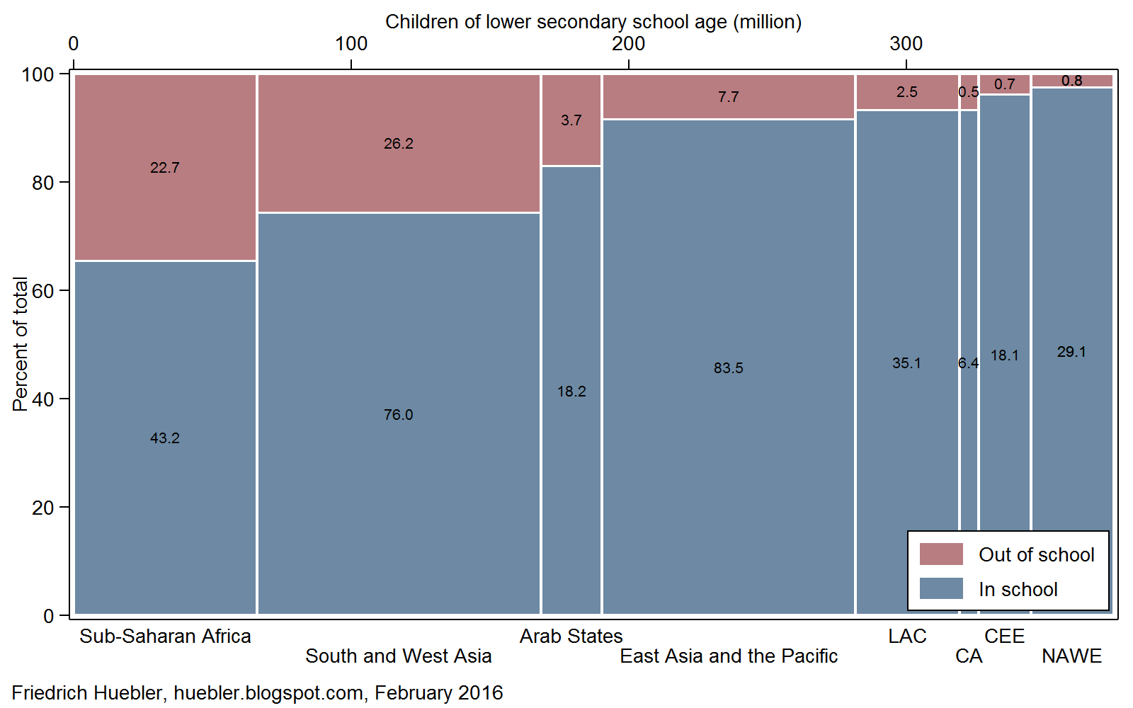
The rate and number of out-of-school children are strongly correlated with national income: in poorer countries, more children are out of school than in wealthier countries.
The World Bank classifies all countries according to their gross national income (GNI) per capita (World Bank, 2017). The map in Figure 1 shows the distribution of countries by income level according to the July 2016 classification. Low-income countries with the lowest per-capita income are concentrated in sub-Saharan Africa.
Figure 1
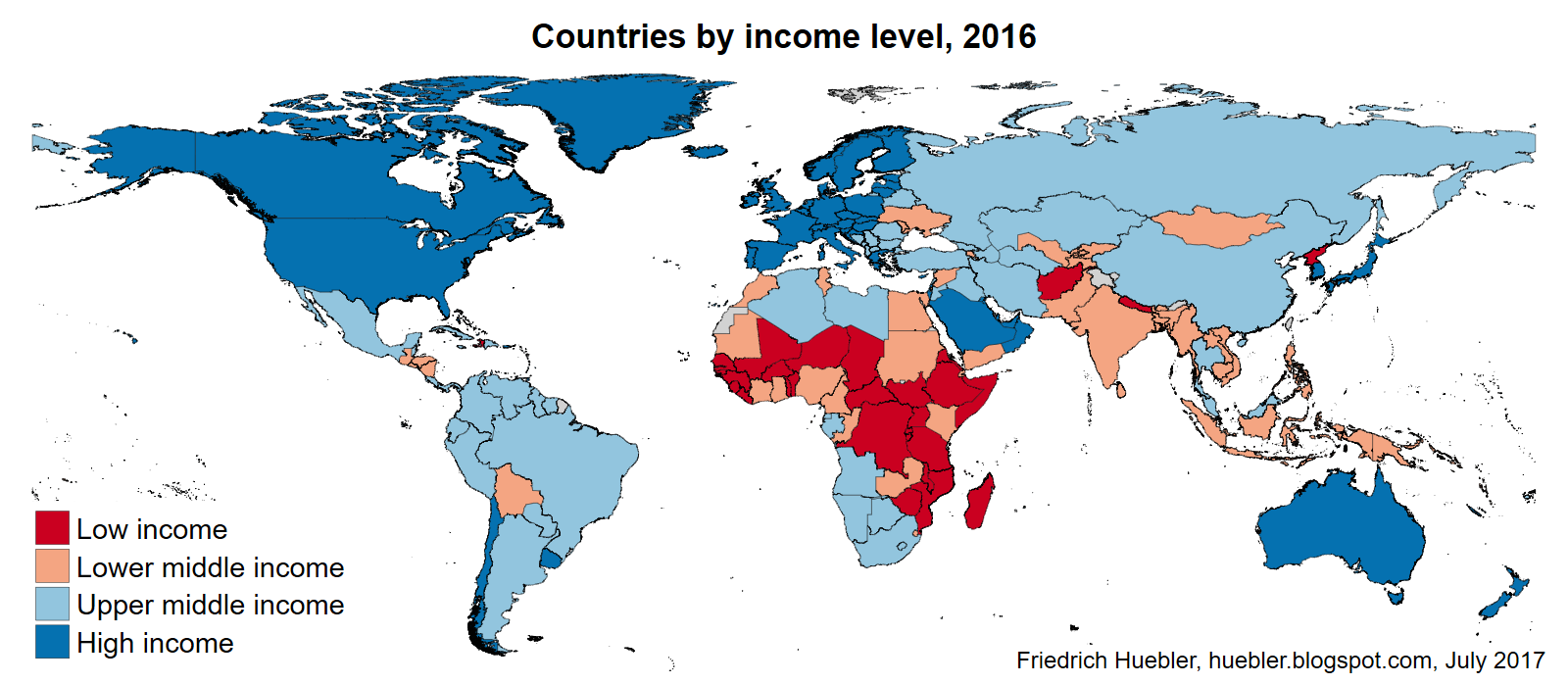
Data source: UNESCO Institute for Statistics
Figure 2 shows that the out-of-school rate decreases with increasing national income. Low-income countries have, on average, the highest out-of-school rates, according to estimates by the UNESCO Institute for Statistics. 19% of all children of primary school age (about 6 to 11 years) are out of school in low-income countries, compared to only 3% in high-income countries. Among adolescents of lower secondary school age (about 12 to 14 years), more than one third (38%) are out of school in low-income countries. The average out-of-school rate is highest for youth of upper secondary school age (about 15 to 17 years) living in low-income countries: nearly two thirds (62%) are not in school.
Figure 2
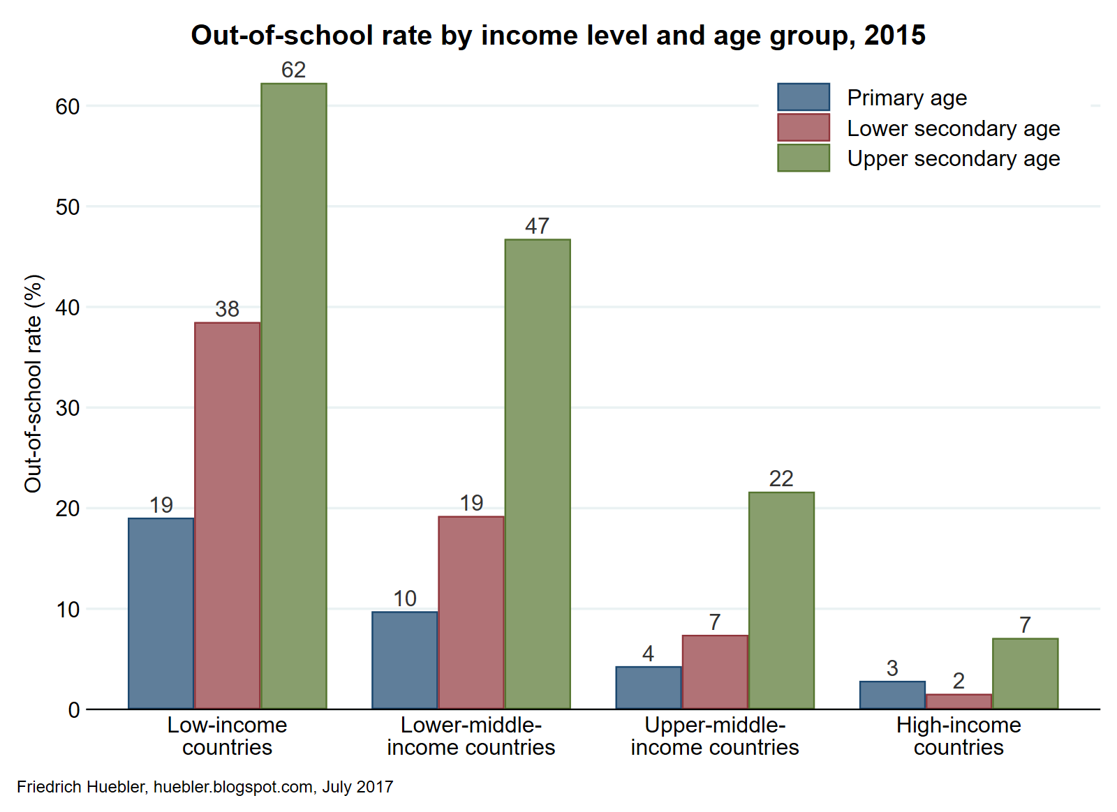
Data source: UNESCO Institute for Statistics
The correlation between national income and exclusion from education can also be demonstrated with national data. Figure 3 plots GNI per capita against the primary out-of-school rate. The highest out-of-school rates are observed among countries with the lowest per-capita income. South Sudan, one of the poorest countries, has the world's highest primary out-of-school rate, with 69%. The absolute number of out-of-school children, indicated by the size of the markers in Figure 3, also tends to be higher in countries with lower national income. The three countries with the largest number of out-of-school children – India, Nigeria and Pakistan – are in the lower-middle-income group of countries. The United States of America stands out as a high-income country with a relatively high rate and number of out-of-school children, but analysis by the National Center for Education Statistics shows that the majority of these children are being homeschooled (Redford et al., 2017).
Figure 3

Data source: UNESCO Institute for Statistics
A recent policy paper by the UNESCO Institute for Statistics and the Global Education Monitoring Report (UIS and GEMR, 2017) examines the link between education and poverty. The paper concludes that reaching the Sustainable Development Goal of universal primary and secondary education could reduce the global poverty headcount (measured by the number of persons living on less than $1.90 per day) by more than 420 million, or more than half of the current number.
References
- Redford, Jeremy, Danielle Battle, and Stacey Bielick. 2017. Homeschooling in the United States: 2012. Washington, DC: National Center for Education Statistics, Institute of Education Sciences, U.S. Department of Education. https://nces.ed.gov/pubsearch/pubsinfo.asp?pubid=2016096rev.
- UNESCO Institute for Statistics (UIS), and Global Education Monitoring Report (GEMR). 2017. "Reducing Global Poverty through Universal Primary and Secondary Education." Policy paper 32/Fact sheet 44. Montreal and Paris: UIS and GEMR. http://unesdoc.unesco.org/images/0025/002503/250392e.pdf.
- World Bank. 2017. "How Does the World Bank Classify Countries?" World Bank Data Help Desk. Accessed 25 May. https://datahelpdesk.worldbank.org/knowledgebase/articles/378834-how-does-the-world-bank-classify-countries.
External links
- Sustainable Development Goals (SDGs)
- UNESCO Institute for Statistics (UIS)
- UIS out-of-school data (UIS Data Centre)
- Global Education Monitoring Report
- World Bank
- National Center for Education Statistics
Related articles
- Regional distribution of children in and out of school
- 124 million out-of-school children in 2013
- Global report on out-of-school children
- Out-of-school children and adolescents, 2000-2012
- Trends in primary school enrollment, 1970-2004
- Universal primary education by 2015: A goal out of reach?
- Global population of primary school age, 2000-2015
- Population structure and children out of school
- National wealth and school enrollment
Friedrich Huebler, 31 July 2017, Creative Commons License
Permanent URL: http://huebler.blogspot.com/2017/07/oos.html